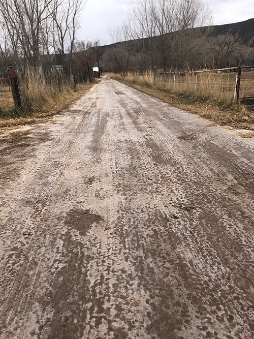
Carol Bondy A reader this week reached out to us. Her property and the property along their road about 1/4 mile north of the Chevron station have seen the water table rise significantly in the past two months as the river water levels have risen. Water is flooding three out of six families living here. This is downstream from where the channel work was done. Water is seeping up from the ground so that the road has been continually wet since November and is worsening significantly. Minerals are leeching from underground and killing all the vegetation. We are wondering if the people living north of us are having similar issues. We believe this situation has something to do with the flood mitigation efforts up river. We would like to organize all being effected by this so we can get help before the spring run-off. I have lived here 32 years, since I bought my property at age 25. I have never seen anything like this here. I have worked very hard to build a home for my daughter. Watching what is happening to my neighbors is frightening. As for the three of us not flooded yet, we will be by Spring. Abiquiu News has reached out to various agencies. We urge the agencies to have a joint town hall meeting. This is a story in progress. Please leave comments if you are continuing to be affected by flooding. Despite dry weather the road has remained wet.
4 Comments
Richard Reinders
1/10/2025 07:15:53 am
I am sure at the rate they are running water it was enough to move rhe loosened sand which once in the water stream slowed in curves or widen sections of the river slowing the stream dropping sand out of the water it won’t be until the run the river at full capacity to will distribute sand over a longer stretch of the river. It’s going to take a full season to mitigate some of these issues.
Robin hardie
1/10/2025 08:17:56 am
We live quite a way upstream on the river. We are having no issues. I feel bad for you and strongly believe that the government is responsible to come finish the correction of the damage that occurred due to the flood and thus, the river diversion.
Richard Reinders
1/10/2025 01:54:36 pm
Robin, the storm that brought in all the sand may have changed the river permanently the government will only do what they have money for. The river has changed course and elevation regularly since the beginning. Thats why they don’t suggest building in the flood plain. I feel for all effected especially those who lived next to the La Madera Arroyo.
Dave Wassil
1/17/2025 08:22:55 am
In 2014 a series of three major floods deposited a 'block' of silt that filled the Rio Ojo Caliente for about 1 1/2 miles. Our property was in the middle of this block. The entire channel was filled and one could walk across from bank to bank and not know it. By that winter the river rose to the top of this silt, which indicated that the ground was saturated outwards at that level. Water began surfacing throughout the property, and much ice formed as small dams formed on a bridge downstream of us and caused the river to back up and flow outwards. Your comment will be posted after it is approved.
Leave a Reply. |
Submit your ideas for local feature articles
Profiles Gardening Recipes Observations Birding Essays Hiking AuthorsYou! Archives
October 2025
Categories
All
|
-
Home
- 10/24/2025
- News 10/17/2025
- News 10/10/2025
- News 10/03/2025
- News 09/26/2025
- News 09/19/2025
- News 09/12/2025
- News 09/05/2025
- News 08/29/2025
- News 08/22/2025
- News 08/15/2025
- News 08/08/2025
- News 08/1/2025
- News 07/18/2025
- News 07/11/2025
- News 07/04/2025
- News 06/27/2025
- News 06/20/2025
- News 06/13/2025
- News 06/06/2025
- Criteria for Submissions
- News and Features
- Dining
- Lodging
- Arts
- Bloom Blog
- Classes
- Activities
- Classifieds
- Tech Tips
- Real Estate
- Real Estate by Owner
- Support


 RSS Feed